
Nima Adventure Trek & Expedition P. Ltd.
Boudha-06, Kathmandu, Nepal
+977-9851114058 · info@nimaadventure.com
Boudha-06, Kathmandu, Nepal
+977-9851114058 · info@nimaadventure.com
Climb Manaslu, the world's eighth-highest mountain and a popular first 8,000 m peak, on a 44-day expedition via the Budhi Gandaki valley and Samagaon.
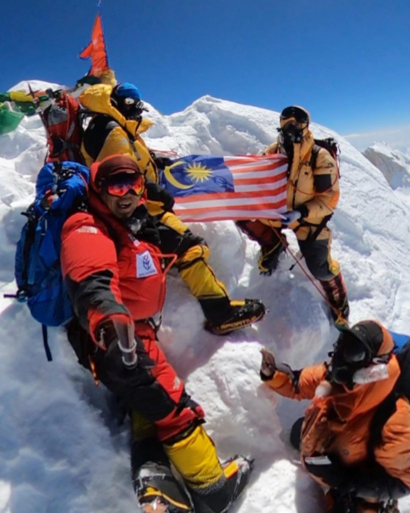
Manaslu, at 8,163 m, is the eighth-highest mountain in the world and the crowning peak of the Mansiri Himal in Nepal's Gorkha district. Its name comes from the Sanskrit word "manasa", meaning intellect or soul, and it is often called the Mountain of the Spirit. Thanks to a relatively straightforward standard route, a well-placed Base Camp above the village of Samagaon and a reliable autumn season, Manaslu has become one of the most popular 8,000 m peaks and an ideal step for climbers preparing for Everest.
Our 44-day expedition begins with a drive from Kathmandu to Machha Khola and a trek up the Budhi Gandaki valley, one of the most beautiful approaches in Nepal. The trail passes through subtropical gorges and Gurung villages to the Tibetan-influenced settlements of Namrung, Lho and Samagaon, with an acclimatisation day built in. From Base Camp at about 4,800 m, the climb follows the north-east face, with camps at around 5,700 m, 6,400 m, 6,800 m and 7,400 m, before a summit day along the narrow, exposed ridge to the true summit.
After the climb, rather than retracing your steps, you complete the classic Manaslu Circuit by crossing the Larkya La at 5,106 m to Bimthang and the Marsyangdi valley, a walk that feels easy with lungs fully adapted to altitude. Each member climbs with a personal, government-licensed climbing Sherpa, and the package includes supplementary oxygen with mask and regulator, fixed ropes, Base Camp staff, individual tents, high-camp equipment and food, and daily weather forecasts. We also arrange the climbing permit, the Manaslu Restricted Area Permit, MCAP and ACAP.
Manaslu is a mountain our team knows well. Nima Adventure has guided Malaysian climbers on Manaslu as well as on Everest and K2, and our Managing Director, Kanchha Sherpa, is a career Himalayan guide who plans every expedition with safety and clear communication at its centre. We keep groups small, work with experienced climbing Sherpas and build enough flexibility into the itinerary to wait for the right weather rather than rush the summit.
This expedition suits fit climbers who have climbed at least one 6,000-7,000 m peak and are confident with crampons, an ice axe, a jumar and fixed ropes. Manaslu is technically more straightforward than most 8,000 m peaks, but the altitude, cold and avalanche risk demand respect, discipline and good judgement.
A Nima Adventure representative meets you at Tribhuvan International Airport and transfers you to your hotel. The rest of the day is free to rest and recover from your journey. If you have the energy, take an easy walk to the Boudhanath Stupa, close to our office in Boudha, and soak up the atmosphere as pilgrims circle the dome at dusk. In the evening we check your documents and insurance details and outline the plan.
Your climbing Sherpa checks your personal equipment, from boots and crampons to down suit and sleeping bag, so that anything missing can be bought or hired in Kathmandu. We complete the climbing permit and restricted area permit formalities and attend the official expedition briefing at the Department of Tourism. In the afternoon you pack your expedition bags, which travel separately to Base Camp, and enjoy a final evening in the city.
We leave Kathmandu early for a long drive of 8-9 hours west along the Prithvi Highway and then north via Dhading Besi and Arughat into the Budhi Gandaki valley. The final section is on a rough, winding road above the river, passing Soti Khola before reaching Machha Khola, whose name means Fish River. We overnight in a simple teahouse and enjoy the warm, subtropical air before the trek begins.
The trail follows the Budhi Gandaki upstream through a narrow gorge, past the hot springs at Tatopani and across suspension bridges, with waterfalls tumbling from the cliffs above. Beyond Dobhan, we climb gently to Jagat, a neat flagstoned village where the Manaslu Restricted Area Permit is checked. The walk takes about 6-7 hours. Keep your passport and permits handy for the checkpoint.
After Jagat, the trail climbs past Sirdibas and Philim, a large Gurung village with terraced fields of millet and maize. The valley narrows into a dramatic gorge, and we cross the river several times before reaching Deng, where the culture begins to shift towards the Tibetan Buddhism of the upper Nubri valley. Expect around 6-7 hours of walking through bamboo and pine forest with the river roaring below.
We cross the Budhi Gandaki and climb steadily through forest past Rana and Bihi Phedi, passing mani walls carved with Buddhist prayers, then on through Ghap, where the valley swings to the north-east. The trail continues through rhododendron and fir forest to Namrung, a village with good lodges and the first views of the snow peaks. The walk takes about 6-7 hours, and Namrung marks the entry into the Nubri region.
A shorter, beautiful day leads through the villages of Lihi and Sho, with barley fields, prayer flags and long mani walls. As you gain height, Manaslu itself comes into view at the head of the valley. Lho sits on a ridge crowned by Ribung Gompa, and from here the views of Manaslu are outstanding, especially in the early morning light. Walking time is about 4-5 hours, leaving time to visit the monastery.
A short walk of 3-4 hours climbs through forest and past Shyala, with a superb panorama of Manaslu, Himalchuli and Ngadi Chuli, to the broad, open valley of Samagaon. This is the main village of the upper Nubri, with stone houses, potato and barley fields and a large monastery, and it is the gateway to Manaslu Base Camp. The afternoon is free to rest and explore the village and its gompa.
To prepare for Base Camp, we take a full acclimatisation day. Options include a hike towards Pungyen Gompa, set in a meadow beneath the glaciers of Manaslu, or a gentler walk to Birendra Tal, a glacial lake below the Manaslu Glacier. Both follow the principle of climbing high and sleeping low. The rest of the day is for resting, hydrating and checking climbing equipment with your Sherpa. Walking time is about 3-5 hours.
A steep climb of about 5-6 hours leads from Samagaon up grassy slopes and then moraine to Manaslu Base Camp, perched on a rocky ridge beside the Manaslu Glacier at about 4,800 m. The height gain is significant, so we walk slowly and take regular breaks. Porters carry the expedition equipment, and our kitchen team sets up camp, including your individual tent and the dining tent. The views of the north-east face are spectacular.
The first days at Base Camp are for rest and preparation. A lama performs the traditional puja ceremony to bless the team and its equipment and ask for safe passage on the mountain. Your climbing Sherpa runs refresher sessions on the glacier near camp, covering jumar and descender work on fixed ropes, crampon technique and ladder crossings, and fits and tests your oxygen mask and regulator. Short hikes continue your acclimatisation.
From Base Camp, the route climbs moraine and glacier to Camp I at about 5,700 m. Above, a crevassed section of glacier with ladders and fixed ropes leads to Camp II at about 6,400 m, crossing an area exposed to seracs where the team moves quickly and early. The first rotation usually involves nights at Camp I and a night at, or a touch of, Camp II, followed by a descent to Base Camp to recover.
After the first rotation, you return to Base Camp to rest, eat well and let the acclimatisation settle in. Some climbers walk down to Samagaon for a night or two in thicker air, which can speed recovery. Meanwhile, the Sherpa team carries tents, fuel, food and oxygen to the higher camps, and we track the weather forecasts closely as the season progresses. Use this time to dry out and organise your kit.
The second rotation pushes higher, climbing through Camp I and Camp II to Camp III at about 6,800 m on a broad, open slope. Sleeping at Camp III, or touching it before returning to Camp II, completes your acclimatisation for the summit push. The ground here is less technical but exposed to wind, and good glacier discipline remains important. You then descend to Base Camp to rest and wait for the summit window.
When the forecast shows calm conditions, you climb in stages to Camp II, Camp III and Camp IV at about 7,400 m, using supplementary oxygen on the upper mountain. In the early hours you leave for the summit, climbing long snow slopes to the summit plateau and then the narrow, corniced ridge to the true summit at 8,163 m. After taking in the views, you descend to Camp IV or lower, and then to Base Camp. Spare days cover weather delays.
We dismantle camp, pack all rubbish and equipment for removal and descend to Samagaon in about 3-4 hours. After weeks on the mountain, the green fields, lodge beds and hot food of the village feel wonderful. Expedition baggage returns down the valley with porters or mules, while you continue on the trekking route with a light daypack. In the evening the whole team celebrates the expedition together.
A short, gentle walk of about 3 hours follows the Budhi Gandaki upstream past mani walls and yak pastures to Samdo, a Tibetan village close to the border, set on a terrace beneath snow peaks. The afternoon is free to rest or wander above the village along the old trading route that once linked Nubri with Tibet. Having climbed an 8,000 m peak, you will find this altitude comfortable, and the scenery is wild and beautiful.
We cross the river and climb steadily across the hillsides above the Larkya Glacier to Dharmasala, also called Larkya Phedi, a basic lodge settlement at the foot of the pass. The walk takes 4-5 hours, and the views of the surrounding glaciers and peaks are impressive. We have an early dinner and an early night, as tomorrow's crossing of the Larkya La begins well before dawn.
Starting before dawn, we climb moraine and snow slopes to the Larkya La at 5,106 m, a broad pass hung with prayer flags and one of the finest viewpoints in Nepal, with Himlung, Cheo Himal, Kang Guru and Annapurna II on the horizon. A steep, sometimes icy descent then leads down to the meadows of Bimthang beneath the west face of Manaslu. It is a long day of 8-9 hours.
The trail descends through rhododendron and pine forest, with views back to Manaslu, to the villages of Gho and Tilije, then joins the Annapurna Circuit at Dharapani in the Marsyangdi valley. The walk takes about 6-7 hours, and the change from high alpine country to green forest and farmland is striking. This is the last night of the trek, so enjoy a final evening with the trekking crew.
A jeep takes us down the Marsyangdi valley to Besisahar, from where we continue by road to Kathmandu, a total of about 9-10 hours depending on road conditions. The road out of the mountains is rough in places but passes through attractive villages, rice terraces and river gorges. After checking into your hotel, enjoy a long hot shower and a relaxed evening in the city.
A free day in Kathmandu to rest, shop or explore heritage sites such as Swayambhunath, Pashupatinath or Patan Durbar Square. Expedition members attend the debriefing at the Department of Tourism, after which summit certificates are issued to successful climbers. In the evening the team gathers for a farewell dinner to celebrate the expedition and thank the climbing Sherpas for their support. This day also serves as a buffer for any travel delays.
After breakfast and final packing, a Nima Adventure representative transfers you to Tribhuvan International Airport in good time for your flight home. If you would like to stay longer in Nepal, our Kathmandu office can arrange a few relaxing days in Pokhara, a wildlife safari in Chitwan National Park or a cultural tour in Bhutan or Tibet. We look forward to climbing with you again.